DRAFTED BY SHUBHAM SHARMA
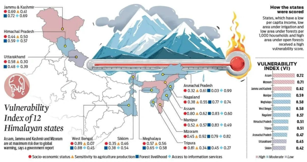
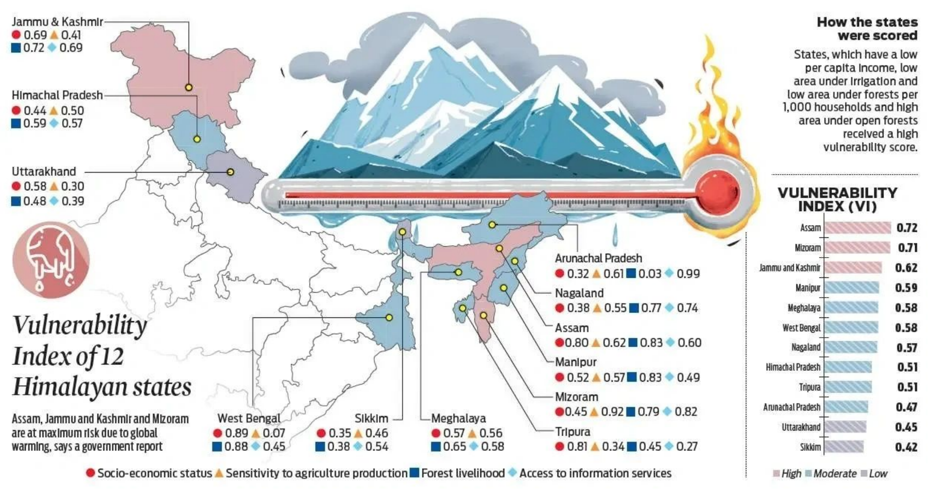
Environmental think tank Council on Energy, Environment, and Water have carried a first-of-its-kind district-level climate vulnerability assessment, or Climate Vulnerability Index (CVI). Under this, it has analyzed 640 districts in India to assess their vulnerability to extreme weather events such as cyclones, floods, heatwaves, droughts, and other natural calamities.
Assessment
The Climate Vulnerability Index (CVI) covers-
Exposure (that is whether the district is prone to extreme weather events)
Sensitivity (Impact on livelihood)
Adaptive capacity (coping mechanism of the district)
It helps in watching critical vulnerabilities and planning strategies to enhance resilience and adapt by climate-proofing communities, economies, and infrastructure. It mainly focuses on hydro-met disasters like floods, cyclones, and drought.
Key Findings of the Climate Vulnerability Index?
- Assam, Andhra Pradesh, Maharashtra, Karnataka and Bihar are most vulnerable to extreme climate events such as floods, droughts, and cyclones in India.
- While 27 Indian states and union territories are vulnerable to extreme climate events, 463 districts out of 640 are vulnerable to extreme weather events.
- Dhemaji and Nagaon in Assam, Khammam in Telangana, Gajapati in Odisha, Vizianagaram in Andhra Pradesh, Sangli in Maharashtra, and Chennai in Tamil Nadu are among India’s most climate-vulnerable districts.
- More than 80 percent of Indians live in districts vulnerable to climate risks – that is 17 of 20 people in India are vulnerable to climate risks, out of which every five Indians live in areas that are extremely vulnerable.
- 60% of Indian districts have medium to low adaptive capacity in handling extreme weather events – these districts don’t have robust plans in place to mitigate the impact.
- North-eastern states are more vulnerable to floods and South and central are most vulnerable to extreme droughts.
- 59 and 41 percent of the total districts in the eastern and western coast states, respectively, are highly vulnerable to extreme cyclones.
- 183 hotspot districts are highly vulnerable to more than one extreme climate events.
Why does India need a climate vulnerability Index?
According to the findings of Germanwatch’s 2020 report, India is the seventh most vulnerable country to climate extremes. Extreme weather occurrences are becoming more common in the country, such as supercyclone Amphan in the Bay of Bengal, which is now the country’s strongest cyclone. Landslides and floods in Uttarakhand and Kerala, for example, have become more common in the last decade.
According to another CEEW(Council on Energy, Environment, and Water) study, three out of every four districts in India are extreme event hotspots, with 40% of districts indicating a swapping trend, in which traditionally flood-prone areas are experiencing more frequent and harsh droughts, and vice versa.
Best performing States?
Assam and Andhra Pradesh are the most vulnerable to extreme weather occurrences, while Kerala, Tripura, and West Bengal are the least vulnerable, according to the CVI. According to the study, the vulnerability of the states ranked differs just a little, making all of them vulnerable. Despite being coastal states and dealing with the threat of storms and floods on a regular basis, Kerala and West Bengal have succeeded admirably. These states have fared better because they have increased their climate action strategies as well as their preparedness to deal with extreme weather.
Cause of the extreme weather events?
Land disruption is the main cause of extreme weather events. Changes in land use, increased construction, and reclaiming land for development are all examples of anthropogenic activity that have resulted in the extinction of forests, wetlands, mangroves, and other habitats. Historically, these ecosystems have served as natural buffers against harsh weather, minimizing the damage. The impact of meteorological events has risen as a result of their removal and is being felt more widely across the country.
Recommendations or suggestions?
- Develop a high-resolution Climate Risk Atlas (CRA) to map critical vulnerabilities at the district level and better identify, assess, and project chronic and acute risks such as extreme climate events, heat and water stress, crop loss, vector-borne diseases, and biodiversity collapse.
- Establish a centralized climate-risk commission to coordinate the environmental de-risking mission.
- Integrate climate risk profiling with infrastructure planning to increase adaptive capacity.
- Undertake climate-sensitivity-led landscape restoration focused on rehabilitating, restoring, and reintegrating natural ecosystems as part of the developmental process.
- Provide for climate risk-interlinked adaptation financing by creating innovative CVI-based financing instruments that integrate climate risks for an effective risk transfer mechanism.